Photographs by Arko Datto
Rain had been falling for several hours on the night of July 18, 2021, when the Tiwaris called their relatives and told them to evacuate their house.
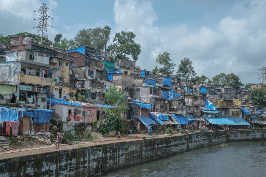
The Tiwaris live in suburban Mumbai, in the hillside shantytown of Surya Nagar, and their relatives were perched in one of a row of single-room tenements atop the steep terrain. Some of those homes had collapsed in a landslide two years earlier and had been recently rebuilt. Now, as the rain thundered on, the Tiwaris began to worry.
Suddenly, the slope disintegrated into a torrent of mud and rock, the sound of the slide drowned out by the heavy rain. Before the Tiwaris’ relatives could make it to safety, their ceiling collapsed. Mud and debris washed down to the Tiwaris’ door. They struggled to get out of their own house, and then out of their narrow lane. By the end of the night, 10 people in Surya Nagar, including three children, had been crushed to death. The Tiwaris lost three family members, and 21 more lives were lost in another landslide nearby.
By the end of last year’s monsoon season, an estimated 50 Mumbai residents had died in landslides or wall and house collapses triggered by heavy rain—one of the city’s worst tolls in recent memory.
In the geography of climate risk, some places are more vulnerable than others, and coastal megacities like Mumbai face the combined threat of rising sea levels and extreme weather events. As their populations expand—by 2050, most of the world’s people will live in urban areas—the paving over of permeable soil for houses and roads further increases the risk of flooding.
Like the rest of India, Mumbai is no stranger to what headline writers like to call “monsoon fury.” The city receives an average of about 94 inches of rain annually, more than double New York’s rainfall, and most of it arrives during the four-month rainy season. For years, the city and its residents have met the monsoon with precautionary measures including the clearing of municipal drains and the plastering of leaky roofs.
Those measures have never been quite enough: The season has long been marked by disruptions in train services, upticks in water-borne diseases, and occasional landslides and building collapses. Mumbaikars have tolerated these hazards in exchange for the economic opportunity offered by India’s commercial capital. People here are known for getting back to work quickly after a disaster, whether the disaster is a terrorist strike or a deluge.
But climate change could stretch Mumbai’s fortitude to its limits. Severe flooding used to occur once every few years. Now, intense-rainfall events occur almost every year. As the number of cyclones in the Arabian Sea increases, sea levels rise, and the city continues to sprawl over floodplains and hills—from 1991 to 2018, the city lost 58 percent of its already limited open space—Mumbai is routinely ranked high on lists of the world’s cities most vulnerable to climate impacts.
City authorities, now finalizing a climate action plan, must confront long-standing inadequacies in housing, drainage, and sanitation, and resolve historical tensions between development interests and environmental protection. Working-class communities in hillside areas such as Surya Nagar may have to think about eventual relocation, however difficult. At every level, Mumbai is facing new dangers and new decisions.
Like many coastal settlements, Mumbai stands on land hewn from water. In the 18th and 19th centuries, British colonists leveled the hills on the small islands of what is now called the Mithi River estuary, using the resulting debris to join the archipelago into a narrow peninsula on the northwest coast of India.
One British official, describing how the original seven islands had been shaken loose from the mainland by tectonic shifts, suggested that the reclamation was fated. “Providence … decreed,” he wrote, “they should be once more united by the genius and energy of man.”
Despite the location’s challenges—malarial swamps, a lack of fresh water, and the need to build bunds and embankments to protect areas at or below sea level—the city became one of the most important ports in the region, a magnet for trade, industry, and labor. “Is it not an astounding feat,” marveled an Indian writer in 1863, “to recover the land from the sea and make it habitable and free of disease and earn lakhs [hundreds of thousands] of rupees in the process?”
During the 20th century, Mumbai expanded to accommodate its growing economy and population. More creeks, streams, and mangroves began to vanish under roads, buildings, and sewage. But every year, the rivers reminded the city of their existence. From June to September, the southwest monsoon sweeps up the west coast of India and into the hinterlands, filling lakes and reconnecting rivers with the sea. For Mumbai, one of the world’s most crowded cities, the season’s cool, clean air and leafy shade is a relief—but it’s also a warning, especially in neighborhoods where the tides once flowed.
The city’s defensive rituals, already well established, have multiplied in recent years. Before the monsoon, people buy umbrellas and plastic footwear. Apartment-building owners and residents repair or waterproof their walls and roofs. During the monsoon, shops in low-lying neighborhoods remove merchandise from the bottom shelves. Commuters brace for traffic or train disruptions and parents look out for school cancellations.
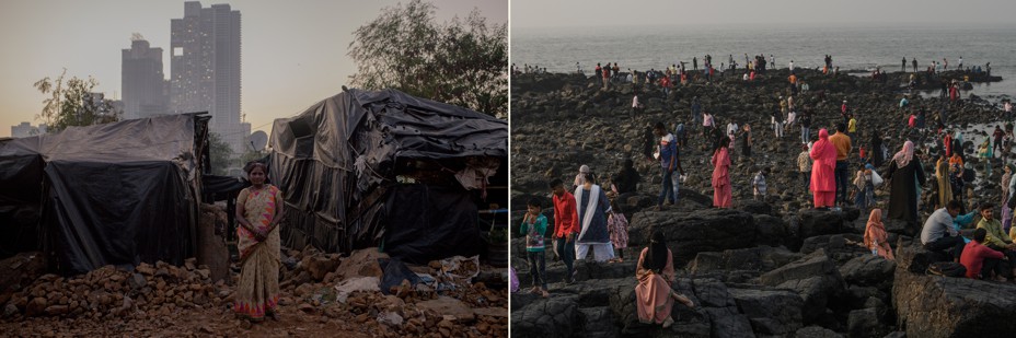
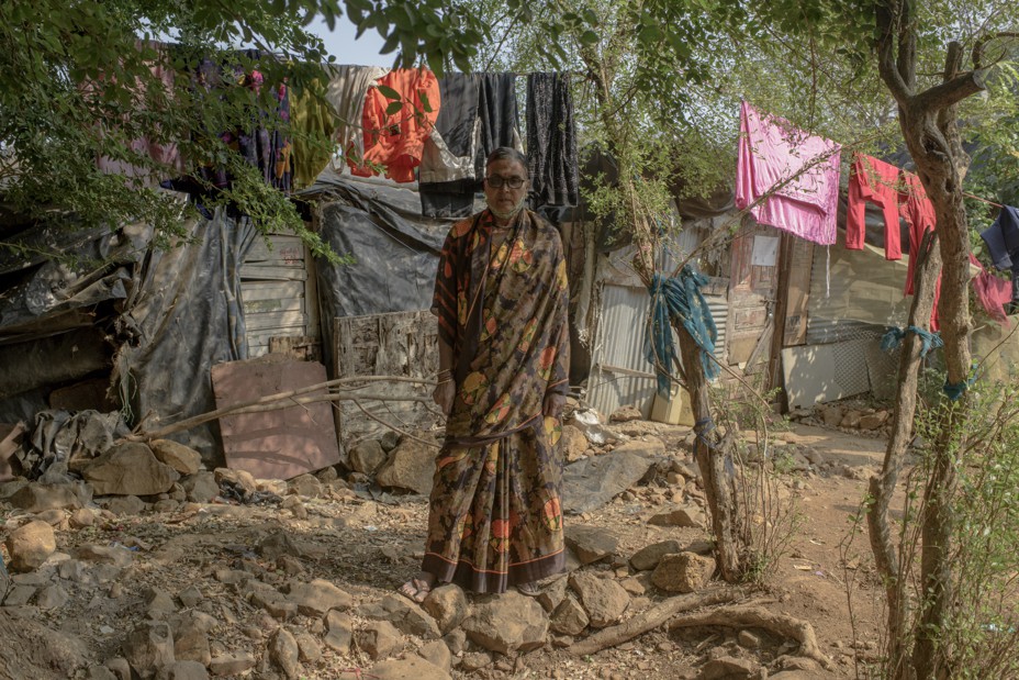
All kinds of improvised measures are on display in Kranti Nagar, a settlement of old and new migrants sandwiched between the airport and a series of metal scrap yards on the banks of the Mithi River. On a weekday in September, the sky is gray and the ground dark from a morning drizzle. Tarpaulins cover Kranti Nagar’s roofs, and clothes are hanging out to dry as best they can. Inside the maze of single- and double-story brick-and-tin tenements, it’s impossible to tell that a river runs nearby. But the residents know.
In a tiny room close to the river, Ranju Devi, a mother of two, reaches up to the light switch just above her head, a little more than five feet from the ground. That’s how high the water can rise, she tells me, when high tides and heavy rain combine and the river swells beyond its banks. Devi and her husband store the family’s clothes and documents on a high shelf so that important possessions don’t get ruined. When the water rises, they take their children and some food to the municipal school, which is located on higher ground nearby. Sometimes, they have to move quickly—one night, she says, she woke up to water at her feet.
The Sonar family, a few twisting lanes away, can afford a double-story tenement. They watch the news for weather alerts and know their escape routine: first switch off their lane’s power mains, then move their belongings and themselves upstairs. On the second floor, they’re protected from electrocution and drowning, but they’re still exposed to the chemicals and sewage in the floodwaters, which cause outbreaks of gastroenteritis, and the malaria and dengue that spread as the water stagnates. But Tulsa Sonar, the family matriarch, doesn’t see a way out of the neighborhood: Kranti Nagar is in the heart of the city, surrounded by schools, hospitals, small factories, and offices. A family of 11, the Sonars would either have to pay three to five times as much to live in more secure housing in the same area or endure long commutes to the city’s schools and jobs. Besides, their local elected representative has promised them a safer home nearby.
The Sonars first moved here from Nepal in search of work in the mid-’70s, when Tulsa was a teenager, and she says there was less flooding then. The problems started when the regional planning agency reclaimed hundreds of acres of mangrove-covered floodplains downstream and covered the newly elevated land with glass-and-steel office complexes. Then airport authorities extended the airport’s runways, narrowing and bending the Mithi River. More settlements and small factories rose along the riverbanks, their sewage and effluent further choking the river’s flow. More recently, the city raised the main road near Kranti Nagar, creating a steep slope to the riverbank settlements.
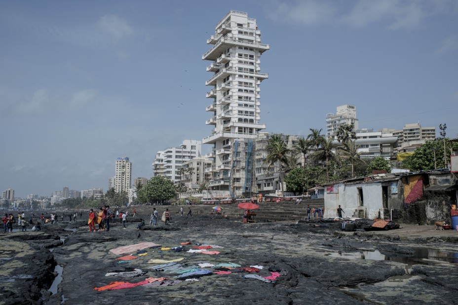
Some wealthy neighborhoods face flooding too. In a prosperous seaside housing development in the western suburb of Khar, ground-floor residents such as Shalini Balsavar move their clothes and valuables to higher shelves during the monsoon. Balsavar has swapped her wooden furniture for sofas and tables with aluminum legs. Flooding in the area started in the ’80s and ’90s, her daughter Reetha tells me, when settlements and residential buildings replaced mangrove stands along the shore, reducing the capacity of the land to drain water. In the 2000s, the problem was aggravated when the city raised the main road, increasing water flow into the Balsavars’ property. Some ground-floor residents in the area have left, while others hope to add extra floors to their building.
The Balsavars own all three floors of their building, so during a bad flood, Shalini can easily move to safety. “We have an alternative,” says Reetha, who lives on the second floor. “Others are not so lucky.”
That “luck” is becoming more important. Instead of steady rain through the monsoon season, Mumbai now experiences more days of heavy rainfall, defined as more than two and a half inches in 24 hours, interspersed with long dry breaks. Throughout western India, extreme-precipitation events increased threefold from 1950 to 2015 due to an increase in atmospheric moisture from a warming Arabian Sea. Research suggests that the short bursts of extreme rain that trigger flash floods and landslides will continue to increase as temperatures rise. The city itself may amplify these trends: Local scientists have found that clusters of concrete structures generate warmer temperatures and atmospheric instability that could be intensifying monsoon rainfall.
And there are new threats: From 2001 to 2019, rising ocean temperatures led to a 52 percent increase in the region’s cyclone frequency and a 150 percent increase in the number of very severe storms, while cyclone duration increased by 80 percent. Mumbai has not suffered a serious hit from a cyclone since 1948, but a few storms have recently come close.
For reasons scientists don’t fully understand, the monsoon season is also ending later, meaning that city residents must stay vigilant into the fall. “We’ve never been flooded in October,” says Kranti Nagar’s Tulsa Sonar, “but this year, who can tell?”
On July 26, 2005, three feet of rain fell on Mumbai, taking more than a thousand lives in flash floods and landslides and causing millions of dollars in damages. In many areas, residents were rescued from rooftops and couldn’t return home for days. Though flooding had been increasing for a decade, the deluge awakened Mumbaikars to the geography of their city—its hemmed-in streams and rivers and its vulnerability to the tides—and the dangers of the monsoon.
Since 2005, civic authorities have spent more and more money on flood-mitigation measures, largely due to prodding from citizens’ groups and judicial orders. In recent years, they’ve begun installing floodgates and pumping stations along parts of the seashore—only six of the city’s 174 stormwater outfalls lie above the high-tide line, so when heavy rain combines with high tide, gates are needed to stop tidal inflow and pumps must physically push rainwater out. Authorities have also set up smaller water pumps along parts of the Mithi River and are experimenting with large underground tanks designed to catch and store water below one of the city’s lowest-lying areas. A long-delayed plan to expand the capacity of the city’s century-old stormwater drains has been revived and updated. And the desilting and unclogging of open drains, streams, and rivers increases every year: By the end of last year’s monsoon, workers planned to remove nearly 220,000 tons of gunk from the Mithi. The city has built retaining walls along some rivers and has improved weather monitoring and disaster-response systems. Now when high tide coincides with heavy rain, evacuation alerts are issued to riverside settlements such as Kranti Nagar.
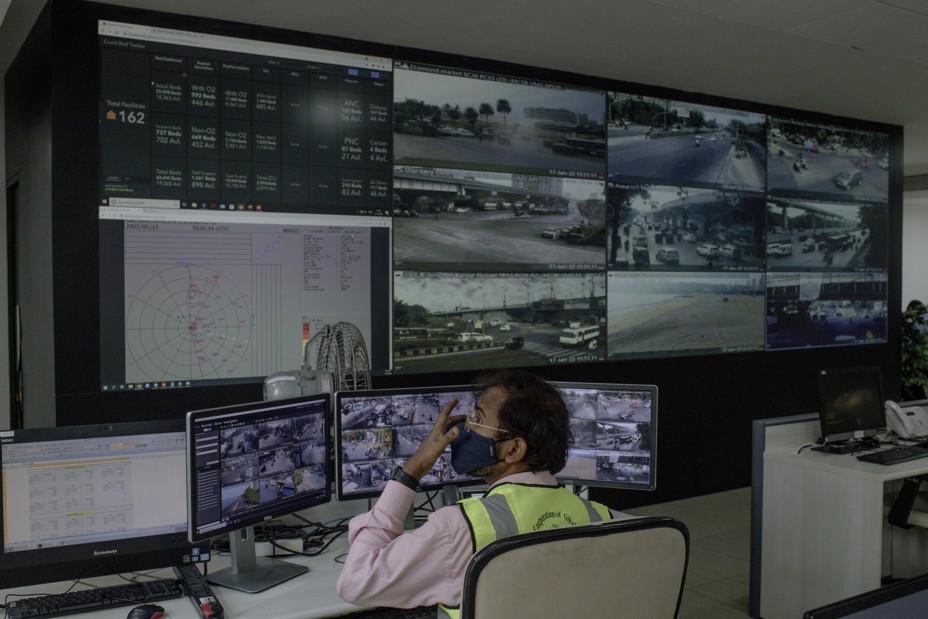
No one knows the limitations of these measures better than Mahesh Narvekar, the head of the municipality’s disaster-management unit. Set up in 2000, the unit became active after the 2005 floods and has been expanding since. The department now runs a state-of-the-art control room in the municipal headquarters, where staff monitor feeds from 60 automated weather stations; 147 hospitals; 5,000 CCTVs; and social media.
During the monsoon season, staff must coordinate responses to instances such as landslides, housing collapses, tree falls, and power outages. Inside the department’s headquarters, an official shows me old CCTV footage of a tree falling on a moving car; passersby leap into action to rescue the motorist. In another video, a car drifts into a flooded street while bystanders watch to see if they need to intervene. “See how our Mumbaikars respond,” the officer remarks proudly, adding that more people should receive emergency training.
Over the past two decades, the unit has dealt with not only floods and landslides but multiple terrorist strikes and a global pandemic. “Disaster response is okay; we can do it. We have the experience,” Narvekar says. But he’s worried about the future. Though the department is working to communicate more quickly with local residents, expand backup-power supplies, and improve its hazard mapping, that may not be enough to protect residents from possible superstorms, or the roughly six inches of sea-level rise expected by 2050.
Even expanded drains and river dredging can do only so much. “How much can you expand [stormwater] pipes and widen streams in a city that’s so densely developed?” he asks. What’s needed, he believes, is a paradigm shift—a climate-adaptation plan equal to Mumbai’s future. “You can’t stop excess inundation,” he says. “The whole city must become a drain.”
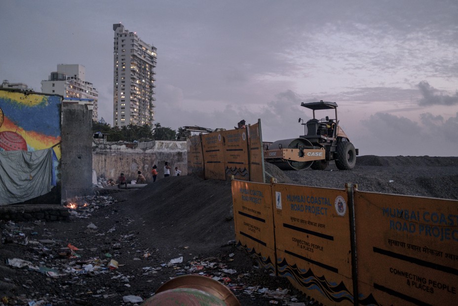
On August 27, state environment and tourism minister Aaditya Thackeray, the environment and tourism minister of the state of Maharashtra, launched the Mumbai Climate Action Plan website in coordination with municipal officials, touting it as the first such initiative of its kind in urban India and South Asia. At the launch, the municipal commissioner, Iqbal Singh Chahal, noted that most of July’s rainfall had fallen in just four days and that cyclones in the region were increasing in frequency. He warned, rather hyperbolically, that much of the office and government district, located in the historic southern tip of the city, could be “underwater” by 2050. Climate change “has come to our doorstep,” he said.
The India office of the Washington, D.C.–based World Resources Institute was entrusted with helping design the climate plan, and its first step was to hold a series of public consultations with local groups and experts. Lubaina Rangwala, the program head of the urban-development-and-resilience team at WRI India, told me in September that her objective was to come up with a “high-level road map” rather than a detailed plan. Engineering solutions such as sea walls, pumps, and underground tanks are important, she says. But like Narvekar, the head of the disaster-management unit, she doubts they will suffice in the long run. “Infrastructure is designed for certain thresholds,” she says. “A tank has a capacity; it can hold a certain amount of water until the tide ebbs and the water can drain.” But if rainfall or tides are extreme, that capacity may fall short, she notes. “The uncertainty of extreme occurrences is what makes us believe that [engineering solutions] won’t be enough.”
In recent years, local architects and researchers have pointed out that walls and other barriers can harden the battle lines between land and water, and have argued that the rivers and sea need to be integrated into the urban landscape—by, for instance, maintaining natural riverbanks that can help absorb overflow. “We do need to see the city as an estuary,” Rangwala says. “We need to think about the percolative nature of the land, and about protecting the natural infrastructures of mudflats and wetlands.”
Development interests have long stood in the way of such measures. After the 2005 disaster, for instance, a high-level state-government committee laid out a series of measures for mitigating floods. Although the city implemented engineering solutions such as pumps, drains, and retaining walls, the recommendations that carried even short-term costs for development interests—such as flood-risk zoning around waterways that would affect the real-estate market—were ignored.
Rangwala acknowledges that in a city driven by commerce, systematic reforms are difficult. But she thinks the political moment is ripe for progress, and not only because of the new global attention on climate change. “We used to say environment was anti-development; now we talk of the two in tandem,” she says. “That change has happened with this [state] government coming in.”
Thackeray, the state environment minister, is a scion of one of Mumbai’s most prominent political families. His grandfather founded the Shiv Sena, a nativist party known for decades for its attacks on migrants from the rest of the country. In 2019, the party took power in the state government after a prolonged tussle with the Bharatiya Janata Party, its erstwhile ally and the party of Prime Minister Narendra Modi. Though the Shiv Sena has dominated the city’s government for two decades, its greater power in the state—along with the rise of new, younger leaders—appears to be reshaping its agenda. Thackeray’s father, Uddhav, the head of the state government, enjoys wildlife photography, and his sons are also interested in ecology: Thackeray’s younger brother, Tejas, a wildlife researcher, has discovered several new species—including a swamp eel, a snake, and a lizard—in the state’s lush and underdocumented Western Ghats mountain range.
The younger Thackerays’ interest in the environment is partly generational, says D. Parthasarathy, a sociology professor at the Indian Institute of Technology Bombay, an elite research institution. Young people in India and around the world are more concerned about climate change and environmental issues, and 31-year-old Aaditya was one of the few state-level Indian politicians to attend the COP26 talks at Glasgow. But the agenda is also politically strategic: Before they took office, both Aaditya and his father backed a popular residents’ movement to save a piece of suburban forest from an infrastructure project, much to the annoyance of their then-allies. They promised to clean up a massive and polluting landfill in another part of the city that had become a political issue for the local community. “The [state] government came to power on such issues,” Parthasarathy says. “They are under pressure to fulfill their promises too.”
That doesn’t mean they can or will break with business as usual in Mumbai. The Shiv Sena government is not halting one of the city’s most controversial and expensive projects, a 29-kilometer coastal freeway along Mumbai’s western waterfront. The road has been opposed by environmentalists and architects who believe it could lead to coastal erosion and flooding while serving relatively few commuters, and by local fishing communities that say their fishing grounds are being destroyed by extensive reclamation. It’s also not clear how the government will handle recently relaxed national-government regulations that permit more development along the coastline. Political parties need funds, points out Parthasarathy, which makes it risky for them to alienate the city’s wealthy developers. He adds that infrastructure projects have their own political logic: “There’s an imagination to [infrastructure], a sense that it represents modernity.”
More than a month after the landslide that killed their relatives, the Tiwaris were still staying with friends in a nearby community. But their neighbors, the Vishwakarmas, had returned home to Surya Nagar, ignoring the warning that the city had pasted on their door. They are a three-generation family of seven. “How long can we stay with friends?” shrugged 29-year-old Sudhir Vishwakarma, the youngest son.
Sudhir and his friends were among the first responders to the landslide; they helped evacuate people and, later, dig out bodies. Ambulances and earth movers couldn’t access the site without destroying homes. The boys didn’t sleep for days, and hardly ate. Since then, every time it rains at night, families in the neighborhood keep their doors open and call out to one another.
Many climate-adaptation projects talk of making cities and communities more “resilient,” more able to cope with or adapt to extreme events like floods and heat waves. But without accompanying efforts to address social vulnerabilities, initiatives to increase resilience can place the burden of adaptation on individuals and on local communities, especially in developing countries, Parthasarathy says.
Mumbaikars’ ability to help one another in times of crisis or bounce back after a disaster is often celebrated by political leaders and the media. But “the spirit of resilience exists out of compulsion,” Parthasarathy says, “because the state is not doing its job. The people must cope somehow.” Resilience also has hidden costs, he adds. Even people who respond stoically to chronic hazards—“water comes and water goes,” as one resident of Kranti Nagar told me—lose time and money in dealing with them, and may sacrifice their health. Interruptions in schooling become more frequent, and saving money becomes more difficult. “People who are busy surviving aren’t able to invest in the future,” Parthasarathy says.
Parthasarathy prefers to use the word transformation. Instead of adapting to and coping with a particular hazard, he says, “we need to reimagine the city and the idea of development.” His research group is working with officials and local groups on a mangrove-restoration project to achieve both environmental and social objectives. Mangroves can mitigate flooding while also providing a livelihood to local fishers, he notes.
For the people of Surya Nagar and Kranti Nagar, transformation might mean moving to safe and affordable housing elsewhere in the city. Because of the lack of affordable options, people who are evicted from hazardous neighborhoods often go and live in even more vulnerable ones, notes Roshni Nuggehalli, the executive director of YUVA, a nonprofit that works with the urban poor. Over the past few decades, the government has tried to incentivize developers to rehabilitate informal dwellings—but many of the resulting housing projects have been poorly constructed or unsanitary. “What we need to address is not the climate event,” Nugehalli says, “but the systemic things that aggravate the climate event.”
After the landslide in Surya Nagar, city authorities quickly announced compensation to the families of those who died—several hundred thousand rupees per life, enough to support a poor family for a year or two but of little comfort to the bereaved. One man lost his wife and two children; he survived only because he happened to be working that night. “If there are no people, what’s the point of money?” asks Jaya, Sudhir’s sister-in-law.
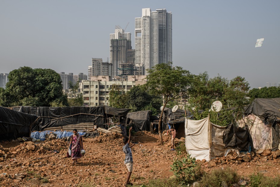
When Sudhir’s late father moved here from northern India more than 30 years ago, the neighborhood was set among forested hills and mangrove stands and surrounded by new factories with jobs for migrant workers. He built a good life for his wife and children, and Sudhir, now an engineer, is one of the first professionals in the family. But he still can’t afford to live in the upscale residential complexes that now crowd the neighborhood.
Sudhir and his neighbors don’t know much about climate change, but they do sense that their home is becoming more dangerous. Many point out that though the 2017 landslide took two lives, last summer’s took 10. (Local officials and politicians likely knew of the danger: In early 2021, an internal report warned of the risk to precariously perched settlements in the area.) Yet most are not ready to leave the neighborhood. Nearby homes down the slope or on level ground are more expensive, and the pandemic’s toll on income and work has put them even further out of reach. Cheaper digs are distant. What they want is for the municipality to protect Surya Nagar with a strong retaining wall. And they seem likely to get it: After the landslide, Aaditya Thackeray directed authorities to speed up retaining-wall construction in unstable areas.
Yet a wall did not help Ambedkar Nagar, a much poorer settlement on the other side of the hill. Its shanties stand above a network of apartment complexes, and just below a water reservoir surrounded by forest. In the 2010s, authorities built a 15-foot-high boundary wall to protect the reservoir from urban expansion. But on one extremely rainy night in 2019, water built up behind the barrier and then broke through. The torrent, carrying chunks of concrete, swept away the bamboo and tarpaulin shanties below, killing about 30 people and injuring another 130. Later, an audit commissioned by the city found that the wall had been poorly designed and constructed. Eighty-six families who had lost homes and relatives were rehoused in low-income developments on the other side of the city; 75 more are still waiting to be relocated.
A few residents have refused to move, including Bomba Devi, a mother of three. When she came to Ambedkar Nagar in the mid-’90s, it was not unusual for leopards from the nearby forest to prowl the hillside. Though she lost a young granddaughter in the flash flood of 2019, she rejected the alternative housing because it was located next to chemical plants and a refinery, and residents there had already fallen ill. (Residents’ health problems were so serious that they sued, resulting in a court decision that blocked the city from relocating people to the area.) Besides, her son works in the local packing firm and her grandchildren go to the nearby public school. To protect her home, she and her children have created small channels and drains in the mud floor that direct the water downstream. Even so, their home is flooded with a foot of water every year.
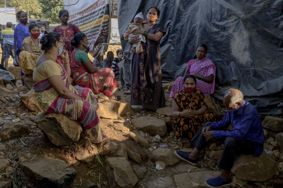
In May, a cyclone brought record rain and winds strong enough to dislodge some boulders above the neighborhood. The residents took refuge in a clearing of sorts—a slightly elevated, flat patch of land kept dry with a thatched roof and strategically dug channels. It was safer than being inside their homes, says Moli Sheikh, Bomba Devi’s neighbor, adding, “We draw strength from being together.”
The morning I visited, more than a dozen residents were sitting in the clearing, participating in an ongoing sit-in. They are demanding that the wall be rebuilt and alternative housing be provided nearby. Many of them had paid into a public-housing scheme intended to provide them with new homes, but so far they have received nothing. “Every time there’s an incident, they come and do a survey” of the damage done and the families that need to be relocated, Sheikh says, pointing to the row of numbers that officials have chalked on his door. “What are they waiting for?”